How to use Second World War Finding Aids
All of National Collection of Aerial Photography's (NCAP) catalogued finding aids for approximately 5.5 million Second World War aerial photographs are available via subscriptions on our classic online platform.
These finding aids show the geographic coverage of photographic reconnaissance missions in the collections. They allow you to locate and identify aerial photographs of your areas of interest.
Once you have identified photographs of interest, you can order copies through the Scan on Demand service.
1: Open our Legacy Website
Navigate to the legacy image viewing platform.
Log in with your NCAP subscription which allows you to zoom and pan images and view all digitised finding aids.
Note: You do not need a subscription to see if there is coverage for your area of interest held in finding aids, however you will need one to view individual finding aids.

2: Zoom to your Area of Interest
Using the search bar or the map tool, find the general area of interest.
Click 'See finding aids in this area', which has the small airplane icon.

3: Refine your Results
You are presented with a list of all the missions, or sorties, linked to the grid square of 10-minutes of latitude and longitude in which your area of interest is located.
You can order this list chronologically by clicking on 'Date'.
If images from this sortie or mission have already been digitised, you should see them presented at the bottom of the page. These can be purchased directly through the Legacy Website.
To examine the finding aids in detail, you will need a website subscription.

4: Examine Finding Aids
Some data is provided for you in the list, but you will need to review each sortie finding aid to see if there is exact coverage offered to meet your needs.
Use the 'Zoom image' feature to open, zoom and pan each image in higher resolution.
Tip: Right-click on a mission of interest and select 'Open link in new tab' so you do not lose your place on the results list.
A new tab will open, showing our record for the selected mission. Since missions often covered more than one location, there may be more than one page. A thumbnail for each page is shown. The map on the right-hand side of the page shows the grid squares covered during the mission.

5: Identify a Photograph
Zoom and pan the finding aid until you find your area of interest. The locations and coverage of photographs are shown by boxes or strips drawn on the map. See if these fall over your area of interest.
Tip: Your area of interest may appear on more than one page, so remember to check all of the thumbnails for each mission.
The photograph frame number is shown in the box. Sometimes frames are only shown at intervals along a strip. For example, you may identify frame 40, but coverage is certainly given by frame 39 and 41 which are not drawn but will be held on the same roll of film.
Tip: For full coverage of Utrecht from this sortie, you would likely order frames 37 to 42, inclusive.

6: Take notes
When you find maps and drawn squares which provide coverage for your area, take note of the exact frame numbers you wish to order.
To order image you must provide the sortie and frame number.
Tip: if you are ordering just a few images from one finding aid, there is a text box on the image page where you can easily input frame numbers for the sortie you are viewing. These will help populate the order form.

7: Order image(s)
As suggested above, you can record the frame numbers of the photographs that you require in the notepad area. Then click 'Order Images'.
Our online order form will open in a new tab. You can select the resolution of copy you require, provide your contact details and tell us how you wish to use the image before submitting your order.

8: Can't identify the right image?
If you are unable to decide which frame covers your area of interest, we offer 72ppi research copies. These allow you to check the coverage and quality of a photograph before ordering a high-resolution copy.
The finding aids may not always be 100% accurate, so we recommend that you also order copies of the frames before and after the one you have identified, to make sure you cover the area you want.
9: No cover of your Area of Interest?
If the finding aid shows no photography of your specific area of interest, close the tab and return to the page of search results. Select another mission from the list and repeat steps 3, 4 and 5.
Once you have examined all of the relevant finding aids, you have completed your search.
More Guides
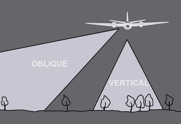
Types of Aerial Images
The capture of aerial photography has most often been been a systematic process. Learn to identify each type and see how they differ.
Scale in Aerial Images
Aerial photographs come in a range of different scales. Learn what impact different scales have on understanding aerial photographs.
Interpreting Aerial Images
Learn more about how to analyse and understand aerial imagery to make the best use of it for your research needs.

How to Order Undigitised Images
Not all NCAP collections are digitised and shared on NCAP's Air Photo Finder. Using the historical finding aids or a paid search service, you can request images for scan-on-demand.

How to use OS Finding Aids
Finding aids show the geographic coverage of photographic reconnaissance missions in our collection.

How to use Second World War Finding Aids
Learn how to use digitised original plotting information, finding aids, from the Second World War. This will allow you to locate and identify historical military aerial imagery of your areas of interest.