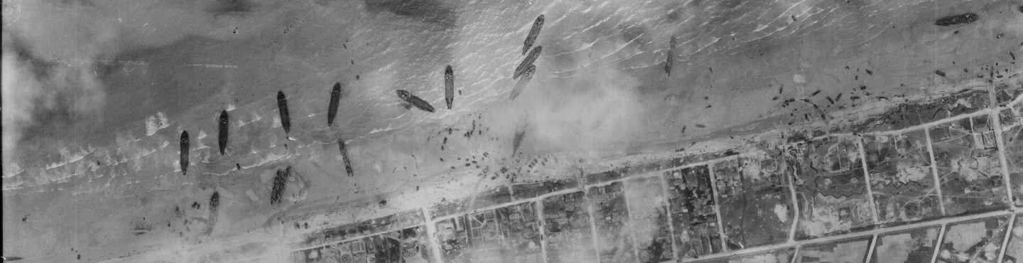
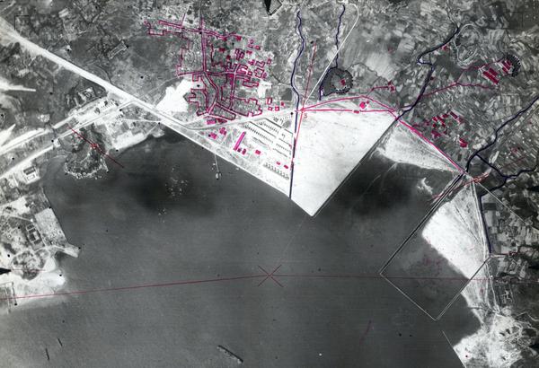
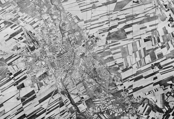
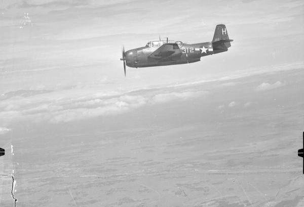
Collection: ACIU, Sortie: US7/1750, Frame: 2072 (06 June 1944)
Landing craft from the first waves of the D-Day landings grounded on SWORD Beach
Collection: ACIU, Sortie: US7/1750, Frame: 2072 (06 June 1944)
Allied Central Interpretation Unit
The Allied Central Interpretation Unit (ACIU) Collection at the National Collection of Aerial Photography is home to 5.5 million surviving images taken for photographic reconnaissance during the Second World War. During this time, ACIU – based at Royal Air Force (RAF) Medmenham, Buckinghamshire – was the Allied headquarters of photographic intelligence. Using stereoscopic techniques, ACIU staff analysed millions of aerial photographs taken over the European Theatre. Their work had far-reaching implications for the conduct of the war and ACIU was involved in the planning stages of practically every operation and aspect of intelligence.
History
Although the importance of aerial photography to military intelligence had been apparent to some since the First World War, it was largely neglected between the wars. In 1938, the aviator and entrepreneur Sidney Cotton was recruited by British intelligence to take clandestine photographs of German preparations for war.
To assist with the interpretation of the photos taken by his unit, known as No. 2 Camouflage Unit and then Special Flight, Cotton enlisted the help of Major Harold Hemming, Managing Director of the Aircraft Operating Company Ltd, an aerial survey firm based at Wembley, Middlesex.
In 1940, the Aircraft Operating Company was officially contracted to the Air Ministry as the Photographic Development Unit – Interpretation and Intelligence (PDUI). Interpretation continued at the Aircraft Operating Company’s Wembley base until expansion and bombing raids forced its move to Danesfield House at Medmenham in April 1941. At the same time, it was renamed the Central Interpretation Unit (CIU).

The initial core group of photographic interpreters at the CIU was drawn from the staff of the Aircraft Operating Company. The unit expanded during 1942 and 1943 and was involved in the exploitation of imagery taken by the Photographic Reconnaissance Unit (as Special Flight became known), to assist in the planning of wartime operations and the assessment of Allied bombing raids. The involvement of United States personnel from 1942 was recognised in 1944 when the title of the unit was changed to the Allied Central Interpretation Unit.
Acquisition
In 1961, the decision was eventually made to transfer a large portion of the ACIU Collection to the University College of North Staffordshire (now Keele University) as an official Place of Deposit under the Public Records Act. In 2006, discussions began between Keele University and The National Archives on the future of the Collection, which had grown with the acquisition of further collections. In 2008 the full extent of aerial imagery held at Keele was transferred to the Royal Commission on the Ancient and Historical Monuments of Scotland (RCAHMS, now Historic Environment Scotland) and became part of the new National Collection of Aerial Photography (NCAP).
Scope
Between 1939 and 1945, tens of million of aerial reconnaissance images recording locations across the world had been accumulated at Medmenham. This vast archive of photographs, taken by British (RAF), American (USAAF), Canadian (RCAF) and South African (SAAF) units, contained a visual record of the world at war. This subset of the vast record which was held at Medmenham covers 34 countries and territories across Europe.
| Geographical coverage | ||
|---|---|---|
| Albania | Guernsey | Norway |
| Austria | Hungary | Poland |
| Belgium | Iceland | Romania |
| Bosnia & Herzegovina | Italy | San Marino |
| Bulgaria | Jersey | Serbia |
| Croatia | Liechtenstein | Slovakia |
| Czechia | Luxembourg | Slovenia |
| Denmark | Macedonia | Sweden |
| Finland | Moldova | Switzerland |
| France | Monaco | Vatican City |
| Germany (except former German Democratic Republic) | Montenegro | |
| Greece | Netherlands | |
Collection Contents
The Collection is made up of:
- c.5.5 million aerial photographic prints
- c.35,000 paper sortie plots.
- 7,500 rolls of 35mm microfilm.
Air Photo Finder
A small amount of this Collection has been digitised and is available to view on the Air Photo Finder.
Subscriptions
Finding aids are available for this Collection and can be examined with a subscription.
ArchivesSpace
The entirety of the Collection is accessible in the Search Room. Visit ArchivesSpace to learn about the Collection hierarchy.
Related reading
IN THIS SECTION
British Aerial Survey Firms
NCAP has extensive holdings of photography taken by several important British aerial survey companies over a period of 50 years.
Defence Geographic Centre
The DGC Collection contains aerial photographs of locations around the world, originally used to create maps for issue to British and Commonwealth forces.
Directorate of Overseas Surveys
The DOS Collection provides a unique historical perspective, recording the changing landscapes of much of the Commonwealth throughout the 20th century.
Environment Agency
The EA Collection is a valuable record of the quickly changing coastal landscapes of the south-east of England, from Bournemouth round to Gravesend.
German Air Force
The GX Collection contains photos taken by the Luftwaffe during the Second World War, which were then used for intelligence purposes during the Cold War.
Joint Air Reconnaissance Intelligence Centre
The JARIC Collection holds millions of Cold War reconnaissance images and forms unique record of British interests and activities.
Mediterranean Allied Photo Reconnaissance Wing
The MAPRW Collection contains c.150,000 aerial photographs taken during WWII by Allied units operating from North Africa and Italy.
Millennium Mapping
NCAP is home to the Getmapping and UK Perspectives Collections, two parallel projects to create a visual record of the UK at the turn of the millennium.
National Archives and Records Administration
The NARA Collection contains worldwide imagery digitised as part of a partnership with the United States National Archives and Records Administration.
Natural Environment Research Council
The NERC Collection contains over 27,300 aerial photographs taken around Europe for research purposes on behalf of the British Geological Survey.
Scottish Office Air Photographs Unit
The Scottish Office APU Collection provides a remarkable, 100-year record of Scotland’s changing landscapes from 1.5 million aerial photos of Scotland.