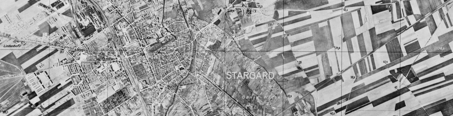
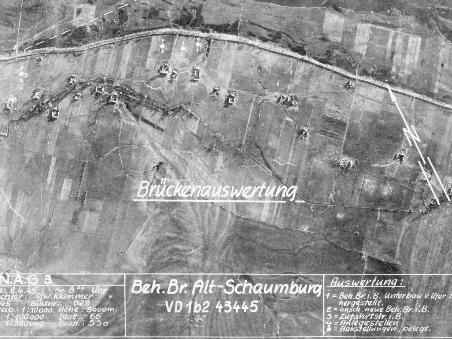
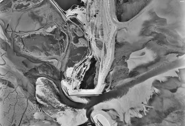
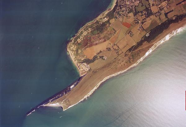
Collection: German Air Force, Sortie: GXM/JARIC, Frame: 4574 (1 May 1938)
The town of Stargard near Szczecin, a year before the German invasion of Poland
Collection: German Air Force, Sortie: GXM/JARIC, Frame: 4574 (1 May 1938)
German Air Force
The German Air Force (GX) Collection contains aerial reconnaissance photographs taken by the Luftwaffe during the Second World War. As the war ended in Europe, collections of this material were found across Europe by American, British and Soviet forces. The German Air Force material would go on to be used for intelligence purposes throughout the Cold War.
History
Like most belligerents during the Second World War, Germany undertook aerial reconnaissance to support its military operations. However, for several reasons this never reached the extent or sophistication of Allied efforts. German aerial reconnaissance was hampered by being decentralised, while the photographic interpreters were poorly trained. They also generally disregarded the use of stereoscopes to view images in 3D which made their interpretation less effective.
As the war ended, the British and Americans discovered masses of German aerial reconnaissance photographs, maps, target dossiers and photomosaics hidden in several locations. Project TURBAN was the code-name for the handling of all the material found. Much material came from Hitler's mountain retreat at Berchtesgaden in Bavaria, Germany and was code-named DICK TRACY, while other large collections were found in Vienna (ORWELL), Oslo (MONTHLY) and Berlin (TENANT).
In June 1945, the material was packaged in crates and flown back to the Allied Central Interpretation Unit (ACIU) at Royal Air Force (RAF) Medmenham, and a joint UK-US sorting and exploitation project began. As the project developed, all the imagery became known as 'GX'. GX was such a large quantity of material that preliminary sorting work continued until 1949. This body of imagery provided the western Allies with intelligence on large parts of eastern Europe and the Soviet Union on a scale unachievable until the advent of reconnaissance satellites in the 1960s.
Until then, much British and American target data consisted of predicted radar imagery of targets derived from GX images. As a joint asset, the imagery was duplicated and shared between the UK and USA. The UK element is cared for by the National Collection of Aerial Photography (NCAP), while the American holdings reside at the US National Archives and Records Administration (NARA). Both NCAP and NARA-held GX imagery is available on the NCAP website.
Acquisition
Following capture, GX aerial photography and photomosaics were transferred for cataloguing to RAF Medmenham. The imagery was subsequently relocated to RAF Brampton, Cambridgeshire, as part of the Joint Air Reconnaissance Intelligence Centre (JARIC) Collection. The aerial imagery was declassified in the early 1990s and released to Keele University in its capacity as an official Place of Deposit, where it joined the ACIU Collection. In 2008, both collections were transferred to the Royal Commission on the Ancient and Historical Monuments of Scotland (now Historic Environment Scotland) and became part of the new National Collection of Aerial Photography.
Scope
The Collection was compiled between 1939 and 1945 and covers 42 countries across Europe, including numerous territories in Central and Eastern Europe such as the Balkans, the Baltic States, Ukraine, and Russia.
| Geographical coverage | ||
|---|---|---|
| Albania | Greece | Norway |
| Austria | Guernsey | Poland |
| Belarus | Hungary | Romania |
| Belgium | Iceland | Russia |
| Bosnia and Herzegovina | Italy | San Marino |
| Bulgaria | Jersey | Serbia |
| Croatia | Latvia | Slovakia |
| Czech Republic | Liechtenstein | Slovenia |
| Denmark | Lithuania | Sweden |
| Estonia | Moldova | Switzerland |
| Finland | Monaco | Turkey |
| France | Montenegro | Ukraine |
| Georgia | Netherlands | Vatican City |
| Germany | North Macedonia | |
Collection Contents
The Collection is made up of:
- c.1.5 million aerial photographs on diapositive aerial film, large-format negatives and paper prints
- associated paper sortie plots
- large-format photo mosaics and annotated target graphics
Air Photo Finder
A small amount of this Collection has been digitised and is available to view on the Air Photo Finder.
Uncatalogued imagery is not currently accessible.
Subscriptions
Subscribe to NCAP to view zoomable images and finding aids.
ArchivesSpace
Visit ArchivesSpace to learn about the Collection hierarchy.
IN THIS SECTION

Allied Central Interpretation Unit
The ACIU Collection is home to 5.5 million photographic reconnaissance images taken during the Second World War, providing a visual record of occupied Western Europe.
British Aerial Survey Firms
NCAP has extensive holdings of photography taken by several important British aerial survey companies over a period of 50 years.
Defence Geographic Centre
The DGC Collection contains aerial photographs of locations around the world, originally used to create maps for issue to British and Commonwealth forces.
Directorate of Overseas Surveys
The DOS Collection provides a unique historical perspective, recording the changing landscapes of much of the Commonwealth throughout the 20th century.
Environment Agency
The EA Collection is a valuable record of the quickly changing coastal landscapes of the south-east of England, from Bournemouth round to Gravesend.
Joint Air Reconnaissance Intelligence Centre
The JARIC Collection holds millions of Cold War reconnaissance images and forms unique record of British interests and activities.
Mediterranean Allied Photo Reconnaissance Wing
The MAPRW Collection contains c.150,000 aerial photographs taken during WWII by Allied units operating from North Africa and Italy.
Millennium Mapping
NCAP is home to the Getmapping and UK Perspectives Collections, two parallel projects to create a visual record of the UK at the turn of the millennium.

National Archives and Records Administration
The NARA Collection contains worldwide imagery digitised as part of a partnership with the United States National Archives and Records Administration.
Natural Environment Research Council
The NERC Collection contains over 27,300 aerial photographs taken around Europe for research purposes on behalf of the British Geological Survey.
Scottish Office Air Photographs Unit
The Scottish Office APU Collection provides a remarkable, 100-year record of Scotland’s changing landscapes from 1.5 million aerial photos of Scotland.